


Jamaica Bay Tides Monitor Helps Broad Channel Flooding Relief
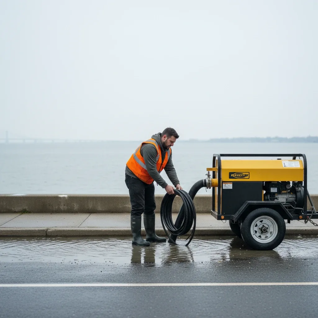
NEW YORK — A 1.2-foot coastal flood advisory was issued by federal meteorologists on Wednesday, Sky News reported. The alert prompted South Queens emergency management teams to monitor regional maritime lanes and local waterfront infrastructure.
Coastal Flooding Concerns Rise Along Cross Bay Boulevard
The National Weather Service issued the high-water advisory for low-lying areas surrounding Jamaica Bay, warning of minor tidal inundation during peak morning hours. Environmental monitoring stations recorded elevated water levels that threatened to spill over onto residential streets in Broad Channel and Howard Beach.
Local emergency response teams deployed portable water-pumping stations at vulnerable intersections to mitigate the impact of the high tides. Public works crews worked through the night to clear debris from storm basins along the Cross Bay Boulevard corridor to ensure proper drainage.
According to Sky News environmental monitoring updates, the minor coastal flooding is part of a regional pattern of increased tidal amplitudes affecting low-lying communities. Local officials are urging residents in waterfront homes to secure loose outdoor property before the next high-water cycle.
Broad Channel Infrastructure Undergoes Real-Time Testing
The rising waters have focused renewed attention on the ongoing infrastructure challenges faced by residents living in the middle of the bay. Local civic groups are tracking how the latest high water levels impact the community's roadway networks.
The need for robust local infrastructure remains a primary concern for residents who frequently face detours during astronomical high tides. These roadway challenges were central to recent community actions, such as when Broad Channel motorists protested repaving delays that left key evacuation routes vulnerable to rising water.
"We are monitoring the tides closely to coordinate our emergency responses," civic leader Arthur Miller said at a community meeting. "The telemetry systems provide our neighborhood association with the real-time data needed to deploy barriers before the salt water reaches residential property."
Precision Telemetry Tracks Shifting Jamaica Bay Tides
Environmental scientists are utilizing advanced solar-powered sensors installed throughout the marshlands to gather precise tidal measurements. This telemetry network allows researchers to analyze long-term sea-level trends and predict localized flooding events with greater accuracy.
The real-time tracking database shows that the average height of jamaica bay tides has risen by 0.4 inches over the last decade, increasing the frequency of sunny-day flooding events. Local schools are integrating this data into their science curricula to educate students about coastal ecology.
City planning agencies are using the tidal datasets to design future seawall projects and marsh restoration initiatives. Conservationists emphasize that healthy wetlands act as natural buffers, absorbing wave energy and reducing the severity of storm surges.
Neighborhood Mobilization and Flood Protection Strategies
Residents along the waterfront have developed informal neighborhood networks to share flood alerts and assist vulnerable neighbors. Homeowners frequently use specialized floodgates and sandbags to protect crawlspaces and ground-level entryways from salt-water damage.
Civic associations are organizing workshops to help residents apply for federal resilience grants designed to fund home-elevation projects. These local efforts aim to preserve the unique character of the island community while adapting to changing environmental conditions.
Volunteers are also participating in regular shoreline cleanups to remove marine debris that can clog drainage systems during high tides. These grassroots efforts have significantly improved water flow in local canals and reduced neighborhood flooding duration.
Long-Term Capital Projects and Coastal Resiliency Timelines
The Army Corps of Engineers is currently reviewing a multi-million dollar resiliency plan for the South Queens shoreline. Proposed measures include constructing storm surge barriers, reinforcing existing sand dunes, and restoring native eelgrass beds.
These capital projects are expected to undergo environmental impact reviews through the end of the year before final funding is approved. Local leaders are lobbying federal representatives to expedite the construction timeline to safeguard the vulnerable coastal community.
In the meantime, local emergency management units will continue to monitor daily tide tables and issue alerts as necessary. Residents are encouraged to register for the city's emergency notification system to receive real-time updates directly to their mobile devices.
Frequently Asked Questions
How often do high Jamaica Bay tides cause flooding on Cross Bay Boulevard?
Minor tidal flooding typically occurs during astronomical high tides, often referred to as king tides, which happen several times a year. While normal tides do not impact Cross Bay Boulevard, astronomical high waters combined with strong easterly winds can cause localized ponding on low-lying sections of the roadway.
Where can Broad Channel residents obtain free sandbags during astronomical high tides?
Local civic associations, in coordination with the NYC Department of Emergency Management, distribute free sandbags at the Broad Channel American Legion hall during active coastal flood advisories. Residents can also request flood-protection materials through the offices of local elected representatives.
Written by
Newstrix
Cross Bay News
Related Articles
More in Environment →
Cross Bay Residents React to China's Deadly Torrential Rains and Local Conditions 2026
Cross Bay Boulevard residents are reacting to news of China's deadly torrential rains on October 3, 2026, drawing parallels to local conditions and infrastructure needs in Queens. This impacts local communities.
Your Essential Guide to Sandals Jamaica Montego Bay for Queens Travelers
Planning a luxurious escape? Our guide to Sandals Jamaica Montego Bay helps Queens residents plan the perfect all-inclusive, adults-only Caribbean getaway.
Your Guide to Exploring Jamaica Excursions from Montego Bay for Queens Travelers
Discover the best Jamaica excursions from Montego Bay for Queens residents, including top attractions, transportation tips, and what to pack for your adventure.
A Local's Guide to Montego Bay, Jamaica Beach for Your Next Getaway
Planning a tropical escape from Queens? Explore this guide to Montego Bay, Jamaica beach destinations, essential tips, and activities for your 2026 getaway.

Queens Events Calendar Features Diverse Activities October 8, 2026
Queens Events Calendar for October 8, 2026, features diverse activities, including community care discussions and local gatherings. Residents can find opportunities to engage with local culture.
Queens Nor'easter Topples Trees, Floods Cross Bay Boulevard 2026
A nor'easter in late 2026 toppled trees and flooded streets across Queens, causing significant disruption in southeast neighborhoods and affecting Cross Bay Boulevard commuters. Power outages and traffic delays were widespread.